Waterfalls & Swimming Holes Near Farmington & the Sandy River, Maine
Farmington river beaches, Sandy River UMF access, Farmington Falls, Smalls Falls on Route 4, and Crosby Falls near Strong—western Maine freshwater on one honest map.
Map of the picks

Farmington sits where the Sandy River threads through college town, farm fields, and the western foothills toward bigger lakes and mountains. That mix is useful for trip planning: you can anchor a day on river sand and eddies, add town falls for a short walk and photos, then drive Route 4 toward one of Maine’s busiest roadside waterfall tiers when everyone is up for crowds and cold water.
This page is a planner, not a live conditions feed. River height, parking, and postings change fast after rain. Use the New England Swimming Holes map, open each linked guide, and match what you see on signs the day you visit.
- Sandy River (Farmington) — UMF beaches — Farmington, ME
- Farmington Falls — Farmington, ME
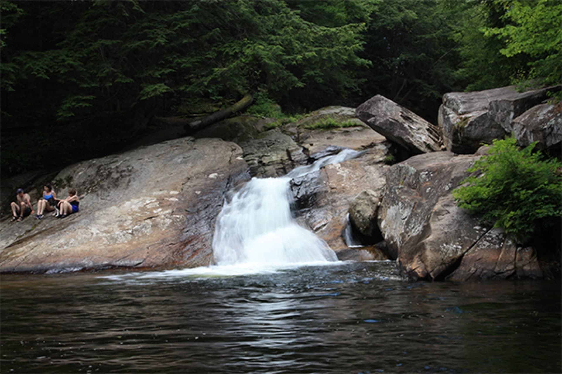
- Smalls Falls — Route 4 / Township E, ME
- Crosby Falls — Strong, ME
Quick picks
| If you want… | Start here |
|---|---|
| River swim framing near campus | Sandy River (Farmington) — UMF beaches |
| A short waterfall stop in town | Farmington Falls |
| A famous Route 4 cascade day | Smalls Falls |
| A quieter brook-falls detour | Crosby Falls |
1. Sandy River at Farmington — river day anchor
The clearest swim-allowed pick for this corridor is the Sandy River (Farmington) — UMF beaches page. It exists because people actually use these sandbars and shallows in summer, but the guide also carries honest language about private land, limited parking, and changing river mood after a thunderstorm.
Read it before you pack towels: cold water, sweepers, and rope-swing culture can all show up in the same afternoon. If the access point feels wrong when you arrive, pivot to a lake day toward Rangeley-area planning or head east toward the Belgrade Lakes planner.
2. Farmington Falls — town context without promising a pool
Farmington Falls is pinned as a waterfall page with swimming not recommended in the place overview. That matters for expectations: you may still enjoy a quick look, mist on a hot day, and a sense of how the Sandy River drops through town, but do not treat the listing as a lifeguarded beach.
Use it as a short cultural stop between breakfast in Farmington and a longer drive, not as the place you promise toddlers will swim.
3. Smalls Falls — big reward, real weekend physics
Smalls Falls south of Rangeley is one of western Maine’s signature tiered roadside stops: a public lot, a short path, and cold green pools that photograph beautifully. It also fills, and the ledge stone stays slick from spray even when the air feels dry.
Open the full guide before you commit the whole car: if the lot is stacked or the brook is pushing after rain, make it a look-only visit. When the scene matches your group’s patience and footwear, it pairs naturally with a Rangeley lake day or a longer loop toward Moosehead country.
4. Crosby Falls — brook scale near Strong
Crosby Falls is a smaller Strong-area waterfall entry—useful when you want forest and brook sound without Smalls-level traffic. The site still lists swimming as not recommended; treat it as a scout-first waterfall stop and read parking notes carefully.
Stewardship and safety (read once, apply everywhere)
- Cold water is normal even in July; wade before you swim and keep shore clothes dry.
- Pack out food trash—roadside sites show litter immediately.
- Posted no-parking lines exist to keep emergency and farm access open; never block gates.
- If thunder is within plausible range, leave the river corridor entirely—narrow gorges are a bad place to wait out a cell warning.
Related regional guides
- Freshwater Swimming Near the Belgrade Lakes, Waterville & Augusta — chain lakes and Kennebec corridor falls when you drive east on US-202 / Route 11 context days.
- Waterfalls & Cold-Water Stops Near Millinocket & the Baxter Gateway — when Farmington is a stop on a longer north woods push.
Updated June 1, 2026