Mud Season Hiking: Which New England Waterfall Trails Are Open in April 2026
A real April 2026 guide to which New England waterfall trails are open during mud season, which are officially closed, and how to hike without damaging fragile trails.
Map of the picks
An honest April 2026 guide to the New England waterfall trails that usually handle mud season, the ones you should leave alone, and what to do when the ground turns to soup.
Mud season is the part of the year New Englanders pretend doesn't exist. Snow is gone, summer isn't here, and the ground is saturated from the top down. Hiking on it churns soft earth into a rut that takes decades to heal. That's why Vermont trail organizations, the White Mountain National Forest, and local land managers ask people to stay off sensitive routes when conditions are soft, and why many trail-damage photos come from April.
The good news: plenty of waterfall trails are built for April. Paved approaches, boardwalks, Trustees walks, state-park paths, and low-elevation gravel trails drain fast and handle the traffic. These are the places you should go.
Start with the New England Swimming Holes map. For state-level planning, use Vermont waterfalls, New Hampshire waterfalls, Maine waterfalls, Massachusetts waterfalls, Connecticut waterfalls, or the Rhode Island hub.
Quick answer
| Question | Answer |
|---|---|
| Hardest-hit state for mud season closures? | Vermont. GMC publishes an official closure list each April. |
| Most reliably open category? | Paved trails, boardwalks, and state-park approaches. |
| Below what elevation is April usually dry? | 1,500 feet in most of NE. Higher in the Whites. |
| Biggest trail-damage mistake? | Walking around mud instead of through it. Widens trails fast. |
| What about southern New England? | Largely fine. MA, CT, RI have short mud windows that clear by mid-April. |
Freshness note
Last reviewed June 1, 2026. This is a mud-season planning guide, not live trail status. Before you drive, check the Green Mountain Club mud-season advisory, White Mountain National Forest notices, state park pages, and recent road status for the exact route.
The 12 waterfall trails reliably open in April
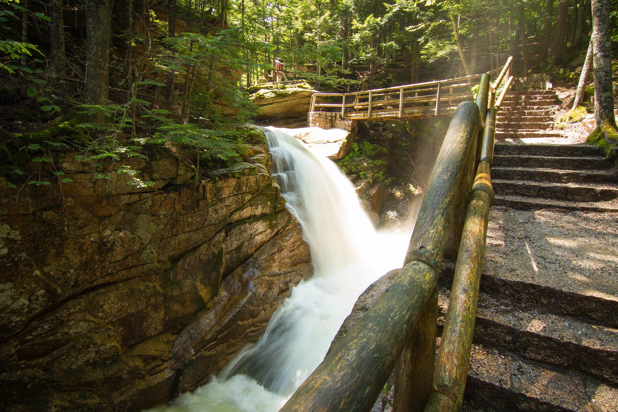
1. Sabbaday Falls — Kancamagus, New Hampshire
Paved path, boardwalk sections over the flume, railings. The most weather-resistant waterfall trail in the Whites. Parking lot is plowed and passable through April. Open the Sabbaday Falls guide.
2. Kent Falls — Kent, Connecticut
Paved stairs run up the side of the cascades, with platforms at each tier. The state park fee is waived until Memorial Day, so April is one of the easiest times to go. Open the Kent Falls guide.
3. Moss Glen Falls — Granville, Vermont
Route 100 roadside. Boardwalk approach keeps boots out of the wet ground. Five minutes from car to falls. Open the Moss Glen Falls (Granville) guide.
4. Glen Ellis Falls — Jackson, New Hampshire
Concrete stairs under Route 16 in Pinkham Notch. A five-minute, no-mud approach. Perfect for a quick stop on a Kancamagus or Crawford Notch day. Open the Glen Ellis Falls guide.
5. Screw Auger Falls — Grafton Notch, Maine
Route 26 roadside within Grafton Notch State Park. The gorge is a two-minute walk from the parking pullout. The trail surface is packed stone and drains fast. Open the Screw Auger Falls guide.
6. Bash Bish Falls — Mount Washington, Massachusetts
Two approach options: a short, steep Massachusetts-side trail from the MA lot, or a gentler three-quarter-mile trail from the Taconic State Park side in New York. Taconic side is better in mud season. Open the Bash Bish Falls guide.
7. Doane's Falls — Royalston, Massachusetts
Trustees of Reservations path, short and well-drained. The four-tier cascade peaks in April. Open the Doane's Falls guide.
8. Enders Falls — Granby, Connecticut
Quarter-mile forest trail in Enders State Forest. Gets muddy after rain but drains within a day. Wear decent boots and you'll be fine. Open the Enders Falls guide.
9. Stepstone Falls — Exeter, Rhode Island
Dirt forest road in Arcadia Management Area to reach the parking, then a short walk to the falls. Drive slowly if it's recently rained. Open the Stepstone Falls guide.
10. Moxie Falls — The Forks, Maine
Approach has raised-plank boardwalks for the wettest sections. Bring waterproof boots for the stretches between boardwalks. The falls are worth the short squelch. Open the Moxie Falls guide.
11. Chapel Falls Trail (Chapel Brook Reservation) — Ashfield, Massachusetts
Short Trustees trail through mixed hardwood. Low elevation, south-facing slope, drains well. Good family April stop. Open the Chapel Falls Trail guide.
12. Wadsworth Falls — Middlefield, Connecticut
Paved trail network through Wadsworth Falls State Park. Spring flow is the best window here. Open the Wadsworth Falls guide.
Trails you should avoid until mid-May
These are not always formally closed, but using them in April causes real trail damage or real risk to you.
Vermont
- Long Trail, high-elevation sections (above 2,500 feet)
- Camel's Hump summit approaches
- Mount Mansfield ridge trails
- Stratton Pond area
White Mountains
- Falling Waters Trail (Franconia Ridge approach)
- Crawford Path above Mizpah Hut
- Tuckerman Ravine
- Huntington Ravine
- Lonesome Lake Trail upper sections after sustained rain
- Dicey's Mill / Sandwich Range ridge trails
Maine
- Bigelow Range
- Saddleback Mountain
- Appalachian Trail above 2,500 feet
- Katahdin (Baxter is closed to overnight camping until mid-May regardless)
If you want the current list of formally closed Vermont trails, the Green Mountain Club maintains a mud season advisory.
State-by-state mud season context
Vermont
The state most affected. VT Forests, Parks & Recreation and the Green Mountain Club treat mud season as a formal conservation period. Stick to roadside waterfalls, boardwalks, town parks, and rail trails until Memorial Day. Vermont waterfalls covers specific trails by accessibility.
New Hampshire
WMNF does not post a blanket April closure, but high-elevation routes can stay snowy, icy, muddy, or avalanche-prone well into spring. The Kancamagus corridor's roadside falls are the safer planning default. New Hampshire waterfalls sorts by access type.
Maine
Baxter State Park is effectively closed to hiking in April, not because of mud but because of snow. Western Maine waterfall trails with road access (Grafton Notch, Smalls Falls area) are fine. Gulf Hagas is gated until mid-May. Maine waterfalls.
Massachusetts
Mud season is brief here. Most state park trails are usable by mid-April. The Berkshires high-elevation trails (Mount Greylock summit loop) may stay muddy longer. Massachusetts waterfalls.
Connecticut
Essentially no formal mud season. All state park waterfall trails open. Some forest roads in Litchfield Hills get soft after rain. Connecticut waterfalls.
Rhode Island
The shortest mud window in New England. Arcadia and Burlingame trails are typically fine by early April. Rhode Island waterfalls.
The three mud season rules
- Walk through the mud, not around it. Going around a mud patch widens the trail and destroys the plant borders that would otherwise recover.
- Turn around if the trail is more mud than ground. That's the signal the soil can't handle foot traffic that day. Trail erosion from April hiking damages routes for decades.
- Wear waterproof boots. Low shoes and sneakers don't survive April hikes and don't protect the trail.
A simple April hiking plan
- Pick a low-elevation waterfall from the picks above.
- Confirm the road is open (state 511 site).
- Check for recent trail reports on AllTrails or the state park's Facebook page.
- Bring waterproof boots, traction, and warm layers.
- Stay on trail surfaces. Don't create workaround routes through mud.
- If the trail is destroyed-looking, leave and drive to a paved-trail pick.
Before you go
- Mud season is a conservation issue, not a weather complaint.
- Most damage happens in the first week after thaw, when the soil is softest.
- Rail trails, boardwalks, and paved park paths are the right April default.
- Dogs in April make the damage worse. Keep them on trail too.
- If you find an unofficial route around mud, don't use it. That's how new damage starts.
Related guides
- Spring Flow Waterfalls in April
- When New England Swimming Holes Warm Up
- Memorial Day Waterfalls
- Easiest Vermont Waterfalls
- Easiest New Hampshire Waterfalls
FAQ
What is mud season in New England?
Mud season is the six-to-eight-week window from late March through mid-May when frozen trail beds thaw from the top down. The soil stays saturated, and hiking on it churns the trail into a rut, widens it over time, and destroys the surrounding vegetation. Vermont and the White Mountain National Forest formally close sensitive trails during this period to prevent long-term damage.
Are Vermont trails closed in April 2026?
Vermont Forests, Parks & Recreation asks hikers to stay off most higher-elevation Long Trail and Catamount Trail sections from April through Memorial Day weekend, though the state doesn't post enforcement closures on every trail. The Green Mountain Club publishes an official mud season advisory list each April. Lower-elevation waterfall trails, boardwalks, and paved approaches are fine.
Which White Mountain trails are closed in April?
The White Mountain National Forest doesn't issue blanket April closures, but discourages high-elevation hikes until the snowpack firms up or melts fully. Specific trails like Falling Waters, Crawford Path above Mizpah, and routes in Tuckerman Ravine are actively dangerous in April. Low-elevation waterfall approaches like Sabbaday Falls, Glen Ellis Falls, Lower Falls, and Rocky Gorge are reliably open.
Can I still hike in April if I stay off muddy trails?
Yes. Paved trails, boardwalks, rail trails, and trails on south-facing slopes below 1,500 feet are typically dry enough in April. The two rules are: don't walk around mud patches (that's how trails widen), and turn around if the trail is more mud than ground.
Is the Franconia Notch parkway open in April?
Yes. I-93 through Franconia Notch is open year-round. The Flume Gorge visitor facility and boardwalk open in early May, and Basin access from the parkway is possible via the shorter roadside pull-off. Higher-elevation trails in Franconia Notch State Park have variable snow and ice conditions through April.
When does mud season end?
In southern New England, by late April most years. In the Green Mountains and lower White Mountains, by Memorial Day weekend. On higher summits (above 3,500 feet in the Whites), trails can stay wet through the first week of June. Check trail reports from the last 48 hours before any mountain hike.
View the next guide
Updated June 1, 2026. Trail conditions change daily in mud season. Check the Green Mountain Club mud season advisory, WMNF notices, and posted signs before heading out.